


The Ocean Exploration Trust's (OET) research vessel Nautilus has departed on its first expedition of 2025 to study underwater volcanoes and deep-sea environments near the Mariana Islands. OET said in a press release that the 22-day mission will investigate some of the most geologically active regions on Earth, including sites within and around the Mariana Trench Marine National Monument.
This area includes over 60 submarine volcanoes and a seafloor spreading center that produces new crust. Scientists aim to study active hydrothermal vents, abyssal plain habitats, and volcanic features through a combination of remotely operated and autonomous underwater vehicles.
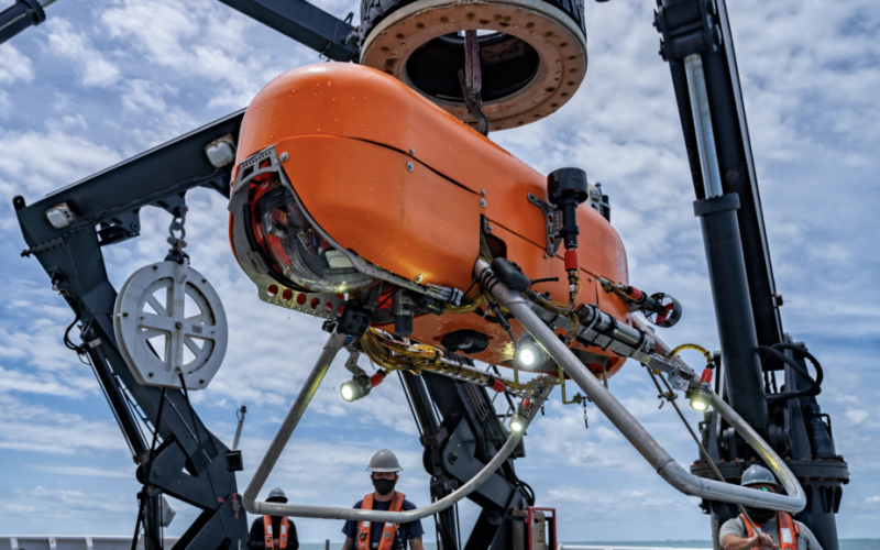
Researchers will deploy the ROV Hercules and Orpheus Ocean’s autonomous underwater vehicle (AUV) Orpheus to conduct deep-sea surveys and collect samples from depths of up to 6,000 meters. The project is supported by NOAA Ocean Exploration, the Bureau of Ocean Energy Management, and the U.S. Geological Survey via the Ocean Exploration Cooperative Institute.
Derek Sowers, expedition leader and OET mapping manager said, “Our mapping systems will be able to detect changes in the seafloor due to recent seismic or volcanic activity, and we will use our deep-diving robots to reveal new discoveries at hard-to-reach hydrothermal vents, volcanoes, and other deep-sea ecosystems.”
The team will focus on identifying geological hazards and biological communities that thrive in extreme environments fueled by chemical-rich hydrothermal fluids.
“The Mariana region is one of the most volcanically active places on Earth, but most of the action is underwater. E/V Nautilus will provide us with the technologies needed to explore these exciting, dynamic sites on the seafloor,” said Bill Chadwick of Oregon State University.
This expedition is one of five planned for 2025. Other missions will take place near the Solomon Islands, the Marshall Islands, and Wake Atoll. Data from these missions will contribute to U.S. and international marine research priorities, including seafloor mapping and resource management.
OET noted mapping and ROV operations will support federal initiatives such as the U.S. National Strategy for ocean mapping, exploration, and characterization.